How to make an Africa map that does the continent justice
An Africa map colors each country by your data, with numbers or with labels. On a map of its own, Africa finally gets the room that world maps rarely give it.
Africa at its real size
Most of us picture Africa from Mercator world maps, which shrink the tropics next to the far north. In reality Africa is larger than the United States, China and India put together. A map of the continent alone fixes the proportions and gives small countries like Rwanda, Togo or Eswatini enough room to be seen. Because Africa straddles the equator, the default projection here is Flat, which keeps the continent close to its true shape.
A map of labels
Not every map needs numbers. When the question is "which group is each country in?", type a word instead of a value, and each distinct word becomes a color with its own legend entry. The map below shows which language a support team answers in, country by country.
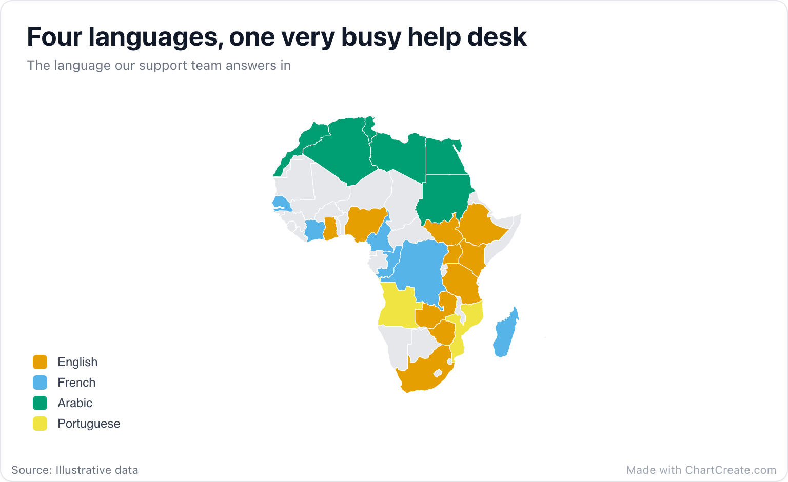
Twenty-four rows and four labels make a map you can read in two seconds: Arabic across the north, French through the west and center, English along the east and south plus Nigeria and Ghana, and Portuguese in Angola and Mozambique. The countries without a row stay gray, and that is information too: markets the team does not cover yet.
Colors everyone can tell apart
A map of labels takes its colors from the palette in the Appearance section, in the order the labels first appear in your data. About one man in twelve has some form of color blindness, most often trouble telling red from green, so the support map uses the Colorblind safe palette, built on the Okabe-Ito colors that stay distinct for the common types. Atlas and Soft are also made for maps. Whatever you choose, stop at about six labels; past that, the colors start to blur into each other.
If two labels need the legend to tell them apart, they need different colors.
Names that trip people up
Two countries are called Congo. On this map, plain "Congo" means the Republic of the Congo, with Brazzaville as its capital. For the much larger Democratic Republic of the Congo, type "DR Congo", "DRC", the full name or the code CD. Côte d'Ivoire matches with or without its accents and as "Ivory Coast", Eswatini still answers to Swaziland, and Cabo Verde to Cape Verde. The example uses two-letter ISO codes (NG, KE, SN), and three-letter codes work too for the most-used countries. Anything that matches no country is highlighted in amber in the Data tab.
On a map of labels you can also skip typing: click a country on the map, pick one of your labels or type a new one, and its row is added for you. It is the quickest way to fill in a handful of countries.
Mind the gaps
The Map section can hide countries without data entirely instead of painting them gray. Think twice before you do it here. A continent with holes in it looks like a printing error, and readers cannot tell "no data" from "not there". Keep the gray, pick a lighter one if it feels heavy, and let the legend do the talking.
And if the point is comparing amounts, say sales per country, a sorted bar chart beats any map for precision; the map is for showing where. Download the result as a PNG, JPG or SVG. It is free with no account, and every export carries a small "Made with ChartCreate.com" credit.